Pin Parvati Pass Trek
-
Duration 5 Days / 4 Night
-
Type Tour Packages
Overview
The Pin Parvati Pass is a thrilling challenge for any seasoned trekker. It’s a long expedition that gives trekkers a massive dose of adventure, beauty and a sense of achievement. The exhilaration of traversing a 17,457 ft pass is an experience of a lifetime.
Pin Parvati Pass trek provides the most spectacular traverses, right from the forest and verdant meadows of the Parvati Valley to the Buddhist villages in the Trans-Himalayan region of Spiti. The sharp contrast in landscapes, culture, flora and fauna will catch you off-guard. Within hours, you’ll walk from cold dry mountain desert region of Spiti to the rich biodiversity in Parvati Valley.
As you climb higher to Pin Parvati Pass, the bird’s-eye view of the Parvati and Pin Valley is fantastic.
Pin Parvati has a host of unique experiences to offer you: from the pulley bridge at Tunda Bhuj to marshlands of Mantalai to alpine meadows of Odi Thach, dense forests near Kheerganga and glacier near the Pass. Pin Parvati trek builds from cold dry deserts of Spiti and its unique settings to the lush, wet greenery of Parvati valley.
Included
- All ground transportation to & fro as per the itinerary.
- Accommodation on twin share in 3 men 4 season tents, sleeping bags/liners, foam mattresses, mess tent, stool, chairs, toilet tent. Single tent available on request.
- All meals during the trek - start with bed tea to breakfast, lunch, dinner, tea /coffee, and snacks. from Indian, Tibetan, and Chinese to continental cuisine.
- Support staff: Qualified English-speaking Ladakhi or local trekking guide, cook & camp crew.
- Trekking porters for porterage of your luggage and trekking gear.Camping fee, climbing permits.
- First aid medical kit.
Excluded
- Domestic flight Delhi - Kullu Manali
- Delhi - Chandigarh - Manali OR Manali - Chandigarh - Delhi transfer. (Booking of a private car on request)
- Travel insurance.
- Soft or hard drinks.
- Entrance fees at monasteries
- Personal tipping to staff: Guide, cook, helper, horseman, driver.
Itinerary Details
An early departure from Manali today. Leaving Manali we drive 84 km to Manikaran (1700 m). Manikaran is famous for its hot water springs and ancient temples. From Bhunter the road goes along the left banks of the Parvati river until Manikaran. Manikaran to Barshaini road distance is 12 km. Setting off a trek from Barsheni ( 2220 m / 7217 ft), we descend to the riverbed and a short ascend to Nakthan. Now an easy trail passes through some small villages and further leads through coniferous forests, waterfalls. Arriving at Rudranag and crossing the wooden bridge above roaring Parvati River, the trail winds up to Khirganga (2850 m / 9350 ft). It is a steep climb up to Khirganga. Khirganga is an open meadow and a hot springs at the distance of 100m up the meadow.
Leaving Khir Ganga today, the trail is muddy through a forest and a steady ascent out of the gorge, where the valley then widens and the trail crosses several delightful pastures supporting a variety of wildflowers in the summer. Mostly now trail goes on flat terrain inside deep thick forests of conifer where it opens up the meadows at sudden. Arrive at the campsite of Tunda Bhuj ( 3250 m / 11023 ft) there are fine alpine views down the valley and waterfalls tumbling down the cliffs on the opposite side of the valley. All the area of Tunda Bhuj is covered with Birch forest.
Today After breakfast, leaving Tunda Bhuj the trail goes through birch groves, rocks, and dense vegetation then the trail descends to the river bank. It is a short trek today as we have to gain only a few hundred meters in elevation. As we leave the tree line behind the trail later gets a bit narrow in rocky. The campsite of Thakur Kuan sits right next to the Parvati riverbed and the campsite is a vast expanse of pasture land. Close to the campsite, there is a trolley bridge mostly used by Shepherds and this used to be the main trail a few years ago and with the wooden bridge right below. Now this wooden bridge has been washed away due to high water in Parvati. Enjoy the afternoon exploring the surroundings.
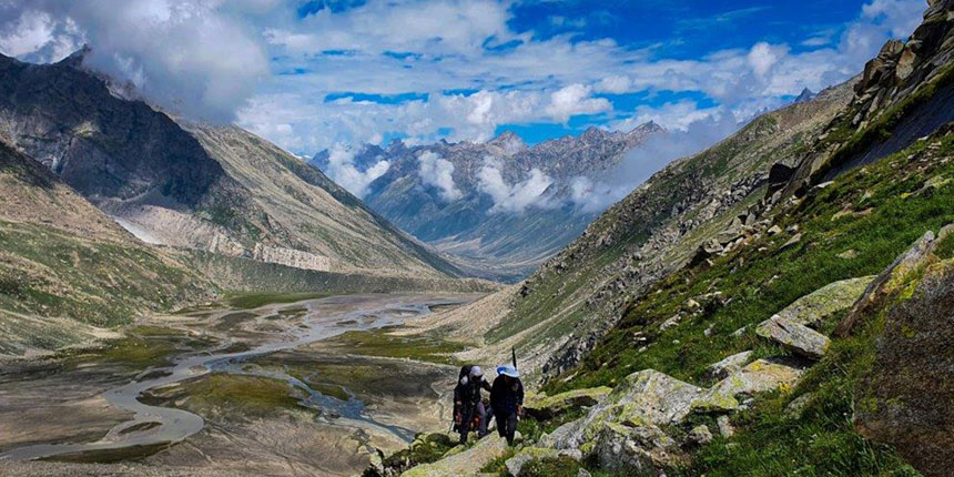
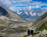
We continue trek along the river and later climb gently and will take you to the first bridge. A short descent down to the river, and to the next massive boulder lying on Parvati River making it a natural rock bridge. This natural rock bridge is called Pandu Pul ( 3680 m). Continue to trail that now on the right of the river. A short climb starts immediately after crossing the bridge for an hour. After finishing the climb vast meadows open up in front of you. All the Odi Thatch area is filled with several Shepherds encampments with flocks of sheep. Thatch means "meadows" in the Kulluvi dialect. The most attractive view from the camp is Kullu Eiger (5650 m / 18530 ft) peaks, which sit in front of Odi Thach and across the Parvati river. We camp at the end of the meadow.
As our trek to Pin Parvati pass continues, we leave Odi Thatch meadows to our next camp of Mantalai. As we gain 300 m in altitude today, so relatively there is no descent but an easy ascent. The trail ascends gradually through a series of flowered meadows intercepted with boulder fields brought down by many side streams. The trail goes along the right side of refreshing Parvati to mini Mantalai. Just before Mantalai, 200 m ascend over the boulders and moraine field to the glacial lake of Mantalai ( 4130 m / 13549 ft). Camp is set on the banks of the lake. This area is also a marshland in the middle of the valley surrounded by mighty Himalayas. A tiny temple is built here with cairns and flags. The grassy shores of Mantalai is perfect spot to relax after trek.
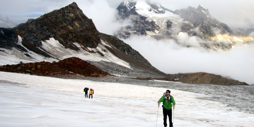
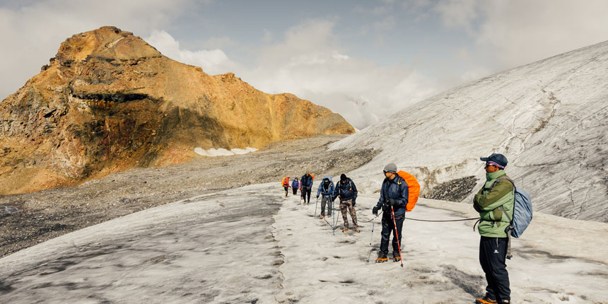
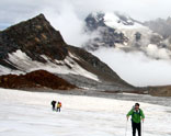
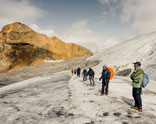
Today is a long and strenuous day, as we have 800 meters to gain in height. We make an early start from the camp and trek along the valley after crossing muddy parts with large sections of loose scree & small streams. We keep left as we climb a steep and steady ridge and the long and hard ascend starts. Trek is now through boulder and scree out of the main valley. The trail crosses a series of rocky terrain before a further steep climb leads to the base of Pin Parvati pass. Our final climb on a rocky ridge takes us to the beginning of the glacier. It is the edge of Parvati glacier. We camp at the edge of the glacier to us a base camp Parvati side (4940 m / 16207 ft). The spectacular view of Parvati South and Pyramid peak can be seen towards west from the base camp.
An early start today, as today is the day for a pass, as we make our way into Spiti. Leaving camp trek across the huge ice and snowfield leading to the pass. We need to negotiate the crevasses and icy slopes on glaciers. Following the guide's trail and footprints we continue making our way to the pass which will take us 3-4 hours to reach the Pin Parvati pass ( 5300 m / 17400 ft). The last part is a bit of a steep climb on a rocky ridge. As the sun moves on, the ice becomes unstable, and hence it's harder to walk to snow. So early starts are recommended when the snow and ice remain hard. Reaching the top before noon also gives a clear sky, as afternoon the clouds from valley starts of appears so the view starts to disappear. The pass offers a wide panorama of peaks and the valley of Spiti. We descend gradually from the pass-first on snow and ice, then steep descent on loose scree. Reaching the foot of the pass, we cross an ice-cold stream and reach the camp at Pin side base camp (4400m ) 14450 ft) on a patch of grass on the left bank of the Pin river.
Today we descend slowly along the left banks of Pin River, walking on the loose rocks and many small streams to cross. Today the landscape changes dramatically as we trek in Spiti, from lush green terrain in Parvati to barren landscape in Spiti. Arrive at the campsite. From camp one can see the route leading towards the Bhaba pass. The valley slightly broadens up here. We camp for the night. The Mudh village is not so far from here.
Leaving camp today, we trek in a wide-open valley with numerous streams spread across its floor. Pin valley landscapes scenery is amazing to watch, with the colors of the terrain to the top of mountains and green at the bottom of a valley. Continue on a trail, we stop for a lunch short before arriving at Mudh. Reaching the first village of Pin valley at Mudh, we stop for a tea break and a homestay shop to taste Himalayan cuisine before heading to Kaza. A short time to spend here exploring the mountain culture and meeting with locals. Finally into the road drive for 2 hours to reach Kaza.
The last day of our Pin Parvati trip. Back to Manali, leaving Kaza we drive to Losar – the last village in Spiti valley, after Losar road climbs up to Kunzum la pass (4551m.), which connects Lahoul with Spiti. The road descends to Batal, we are now in Lahaul valley. Along the Chandra river for hours before entering the Atal Tunnel to Dhundi and passing Solang Nala to Manali. End of the trip.